
Specialist AI agents · coupled to your assets and your data
We do not sell weather. We sell the decision.
Forecasts are a commodity: they are in every phone. What changes your operation is what you do with them — on your asset, with your data, inside your systems.
Platforms
Three platforms, one decision each
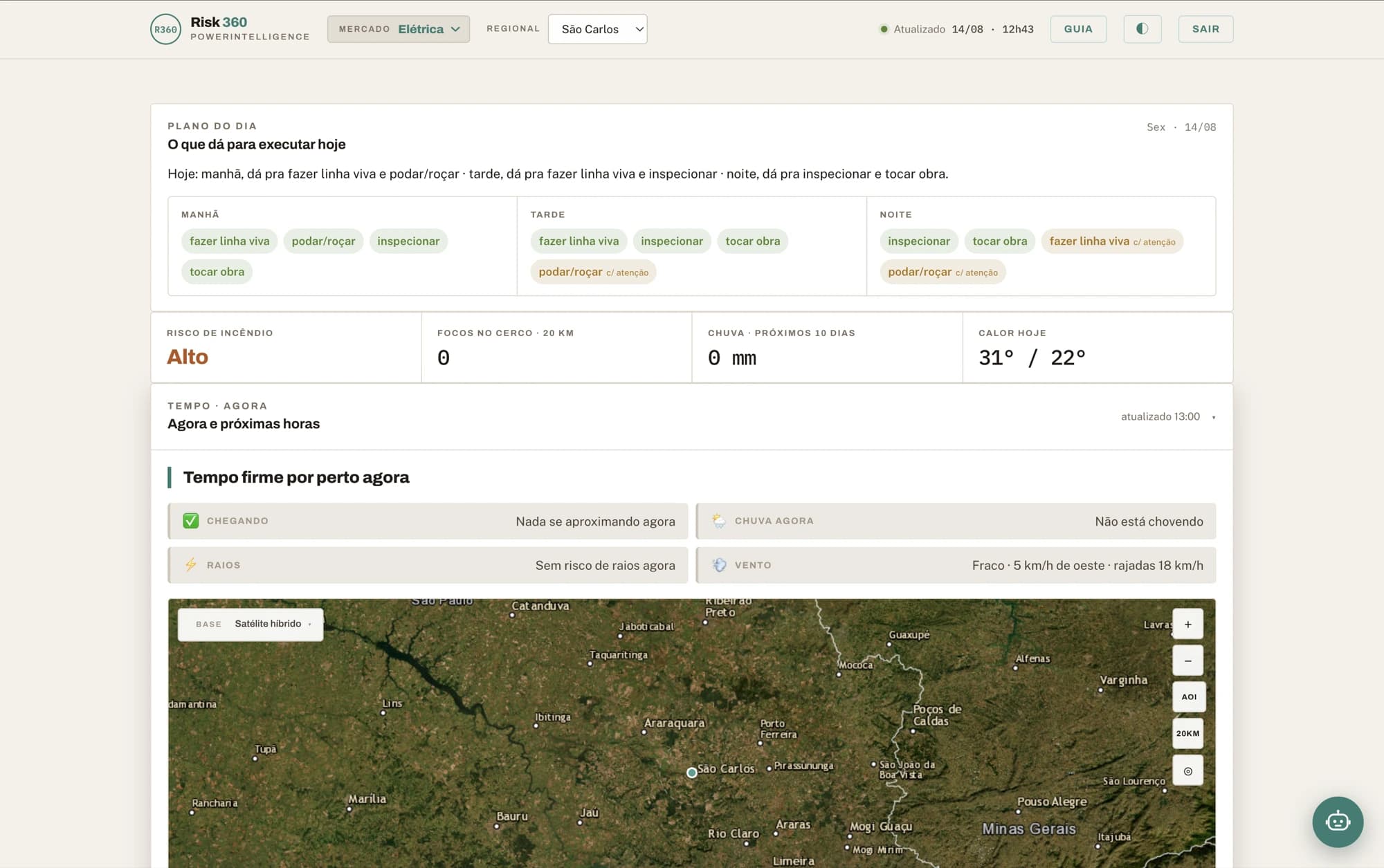
Risk360 decides what the crew does over the next ten days. Climate Edge decides where the next decades’ capex goes. MapsAI answers where — in natural language, over the map you already have.
Risk360
Climate intelligence that becomes an operational decision.
From storm nowcasting to the six-month trend: risk on every critical asset, action prioritised in the right windows, and response sustained through the crisis.
Explore Risk360Climate Edge
Long-term climate governance, with numbers that survive an audit.
Climate scenarios translated into physical risk on each asset — to decide where to invest, what to reinforce and what inaction will cost, with documented methodology and stated uncertainty.
Explore Climate Edge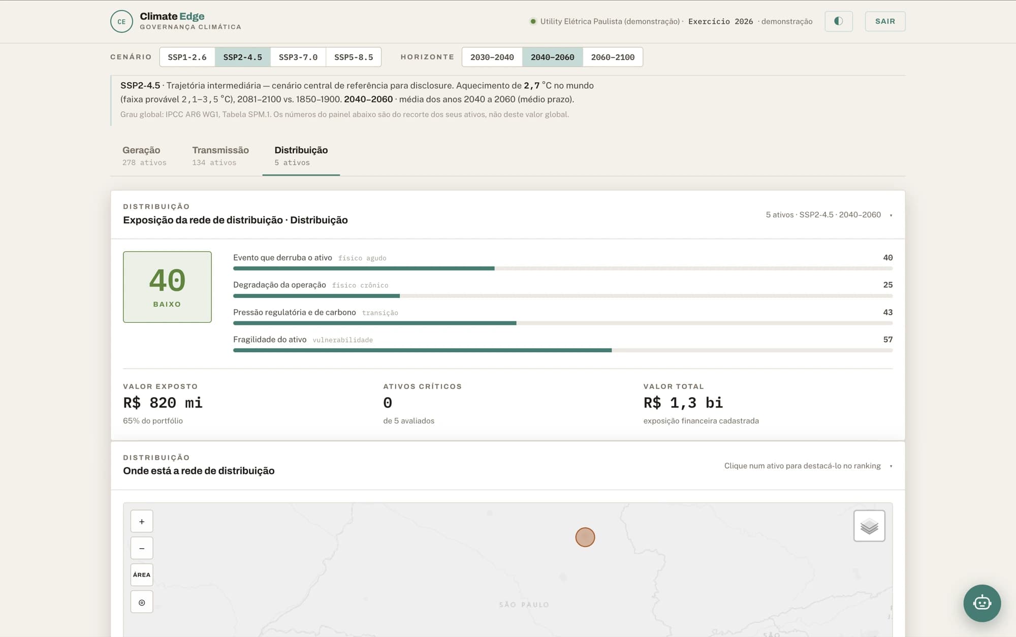
MapsAI
Ask your map. In your language.
An AI agent over your maps: ask in Portuguese, English or Spanish, get back a map and a number — no GIS, no spreadsheet, no queue.
Explore MapsAI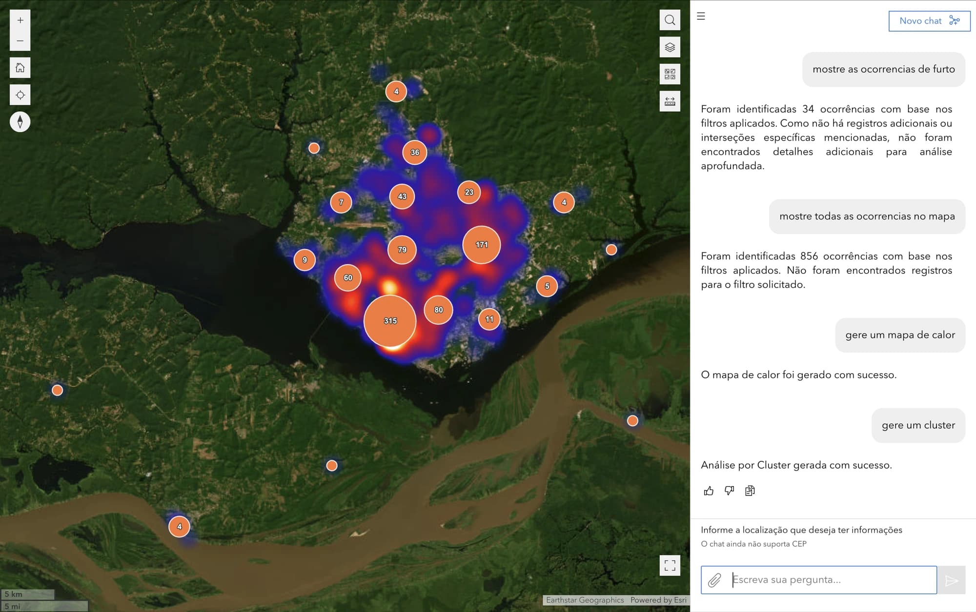
Engines
The engines, also sold separately
Teams that already have their own dashboard can license just the model, over an API. Same technology that runs inside Risk360.
Weather Trends
Storm nowcasting, a high-resolution 10-day forecast and a 6-month seasonal trend — from one engine.
Three horizons under one contract: the storm minute by minute, the ten days on grids down to 2 km, and the anomaly for the next six months.
ExploreWildfire Sentinel
Wildfire risk on a 10-day horizon, with spread remodelled every 20 minutes.
Detection, risk and spread cross-referenced against your registry: the alarm carries the asset name, the distance in metres and an estimate of the hours until the fire reaches it.
ExploreBring us your challenge
See the decision on your assetsA weather bulletin is a commodity. A decision about your asset is not.
AI agents
AI agents before the forecast.
Agents that read the risk, explain it in natural language and recommend the action — under human supervision, with guardrails and an audit trail. The forecast is the input; the answer is the product.
AI agents that explain
The manager asks in their own language and gets the day’s risk reading, with the reasoning. Not one more report to read — the conversation that replaces the alignment meeting.
The engine decides, the AI explains
In regulated domains risk classification is deterministic, versioned and auditable. The AI interprets and guides; it never classifies the risk. That is what makes the result survive the auditor.
Human in the loop
Agents call tools and propose action, but a person signs. Guardrails and an audit trail on every decision — human-in-the-loop is architecture here, not a slogan.

Specialist agents
A specialist AI agent per sector. Not a generic chatbot.
Every platform carries specialist AI agents for the sector of whoever is asking — and “specialist” here is not a brochure adjective. It is not the same model with a new name: the vocabulary, the activities, the thresholds and what counts as risk all change. The proof is in the question each one answers.
Power utilities
“Can we do live-line work tomorrow morning?”
Agriculture
“What is the best spraying window this week?”
Water and sanitation
“Can I clear confined-space entry this afternoon?”
Telecom
“Which site loses power first if the front arrives?”
Infrastructure
“Any hotspots near the right-of-way?”
Civil defence
“Which flood scenario does this rainfall trigger?”
Where the team already is
Text
A conversation inside the dashboard, next to the map and the numbers the answer came from.
Voice
The day’s reading spoken aloud, for people whose hands are busy — in the vehicle, at the substation, in the field.
Question and answer in the app the field team already uses. Nothing to install, nobody to train on a new tool.
How much the agent does
Two modes, and the difference between them is how much work you delegate — never how much of the decision.
Copilot
The agent follows along and weighs in: it reads the day’s risk, explains the reasoning and recommends the action. The team still drives — the agent steps in when called, on screen, by voice or on WhatsApp.
Autopilot
The agent runs the whole routine: it monitors, joins the data to the registry, prioritises and leaves the action ready to go. What is left for the person is the one part nobody delegates: deciding.
How the decision is produced
Four steps between the data and what somebody signs.
It is the whole chain that makes the result worth anything, and it is where most fail: anyone can put a good-looking number on a screen; few can say where it came from and what it means for your asset.
1
Declared source
Where the data comes from and how far it reaches. An asset outside the source footprint is flagged immediately — never filled in with a plausible value from a neighbouring cell. A field the source does not publish arrives absent, not zeroed.
2
Deterministic engine
Risk classification comes from versioned rules, not from a language model. Same input, same number, every time — the precondition for an auditable result.
3
AI agent explains
The agent reads the result and writes the reasoning in that sector’s language, for text, voice or WhatsApp. It interprets and guides; it does not classify risk and does not recommend investment.
4
Alert on your registry
The number touches your asset — line, segment, station, building — with the distance attached. Without that join it is a hot pixel on a map, and a hot pixel moves nobody.
Coupling
Coupled to your assets and your data.
Our platforms do not ask you to switch systems or migrate your base. They plug into what already runs in your operation — and when you only want the clean data, it arrives over an API, inside the dashboard you already have.
Integrates with what already runs
ERP, SCADA, OMS, ArcGIS, Cell Broadcast and alerting systems. Risk shows up where the team already works, not in one more tab open all day.
Data as a Service
Forecasting, wildfire risk, hydrology and long-term climate projection delivered over an API, under a stable contract. Consume the model without buying the platform, and without discovering the schema by trial and error.
See detail
It ships with a variable dictionary generated from the services themselves: field by field, with type, unit and the range measured on real samples.
Agents as a Service
The specialist AI agents answering from inside your systems and your team’s WhatsApp — as a copilot that recommends, or as an autopilot that does the work and hands the decision over ready for someone to sign.
Maps as a Service
Georeferenced layers and maps as a service, ready to feed dashboards, field applications and your own AI agents.
Data in Brazil, and MapsAI inside your perimeter
Everything runs with data hosted in Brazil, LGPD compliance and full traceability of decisions. And when the contract requires the data to stay in the building, MapsAI runs inside your security perimeter.
- ERP
- SCADA
- OMS
- ArcGIS
- Cell Broadcast
- Alerting systems
- API · DaaS
Why now
Risk left the scenario and landed on the balance sheet.
For twenty years climate was a topic for a 2050 report. The last two years billed it early — and over the same period, the ruler measuring companies changed hands.
The climate already billed
The 2023–24 super El Niño
One of the strongest on record. Record heat, severe drought in the Amazon, and a fire season that looked like no previous one.
Rio Grande do Sul, May 2024
The largest flood in the state’s history. Operations, assets and entire cities halted at once — and no risk spreadsheet had that scenario in it.
The 2024 wildfire crisis
Simultaneous fire across several regions, with transmission lines, railways and crops in its path. Those who had the hotspots mapped acted; those who did not, watched.
The ruler changed hands
The financial sector is still bound
BCB 139, CMN 4.943 and SUSEP 666 still require banks, insurers and asset managers to manage and disclose climate risk. If you borrow or insure, the requirement reaches you second-hand.
Adaptation became law
Lei nº 14.904/2024 set the guidelines for climate adaptation plans across all levels of government and across sectors. A plan needs a diagnosis, and a diagnosis needs data per asset.
At the CVM it stopped being a duty and became an edge
Resolução CVM 244, of May 2026, made voluntary the IFRS S1/S2 reporting that CVM 193 would have made mandatory. The pressure did not disappear: it moved. Whoever reports now does it because investors, banks and clients ask — and whoever reports well separates from whoever does not report at all.
Regulation moves. This section reflects what stood in August 2026; if you are reading it much later, check before deciding on it.
A number only becomes a decision when it touches your registry.
Where we have been
Before we were a product company, we were a team in the crisis room. That is where what we build comes from.
Power utilities
Real climate risk cases over transmission assets in operation.
Rio Grande do Sul
National response to the climate disaster.
2024 wildfire crisis
Supporting the fire brigades through the emergency.
São Paulo and Santos civil defence
Joint monitoring and response operations.
Clients
Agribusiness, engineering, geospatial technology and international organisations — the same decision machinery, in contexts that look nothing alike.
- Vega MonitoramentoTraceability and intelligence for agribusiness, monitoring agricultural assets and socio-environmental compliance.
- Imagem GeosistemasEsri’s official distributor in Brazil. Both a client and a partner.
- GeohidroConsulting engineering in infrastructure, environment, sanitation and water resources.
- UNHCRThe UN Refugee Agency, in Brazil.
- UNDPUnited Nations Development Programme, in Brazil.
Technology partners
We do not rebuild what already exists and works. The geospatial foundation, the sensors and the cloud come from the people who do it best — and that is what our models run on.
 EsriGlobal leader in geographic information systems and creator of ArcGIS, the geospatial foundation the platforms run on.
 Imagem GeosistemasEsri’s official distributor in Brazil, for geospatial technology, data and training.
 ZukkGeographic intelligence: GIS, Geo AI and bespoke development on the ArcGIS platform.
 Leica GeosystemsPrecision sensing and measurement — the field data that underpins the asset registry.
 Google CloudWe are a Google Cloud Partner: the platforms run on the cloud, with data hosted in Brazil.
Consulting
Climate science applied to your decision
Risk diagnostics, legally mandated adaptation plans, regulatory reporting and situation-room design — from people who have been in the crisis room.
See consultingTechnology
From science to software in production
Proprietary climate and geospatial models, enterprise platforms and AI agents, built and maintained by a senior team.
See technologyBring us your challenge
If it involves climate, territory and data, it is our ground. The conversation starts from a real slice of your operation — not from a deck.